
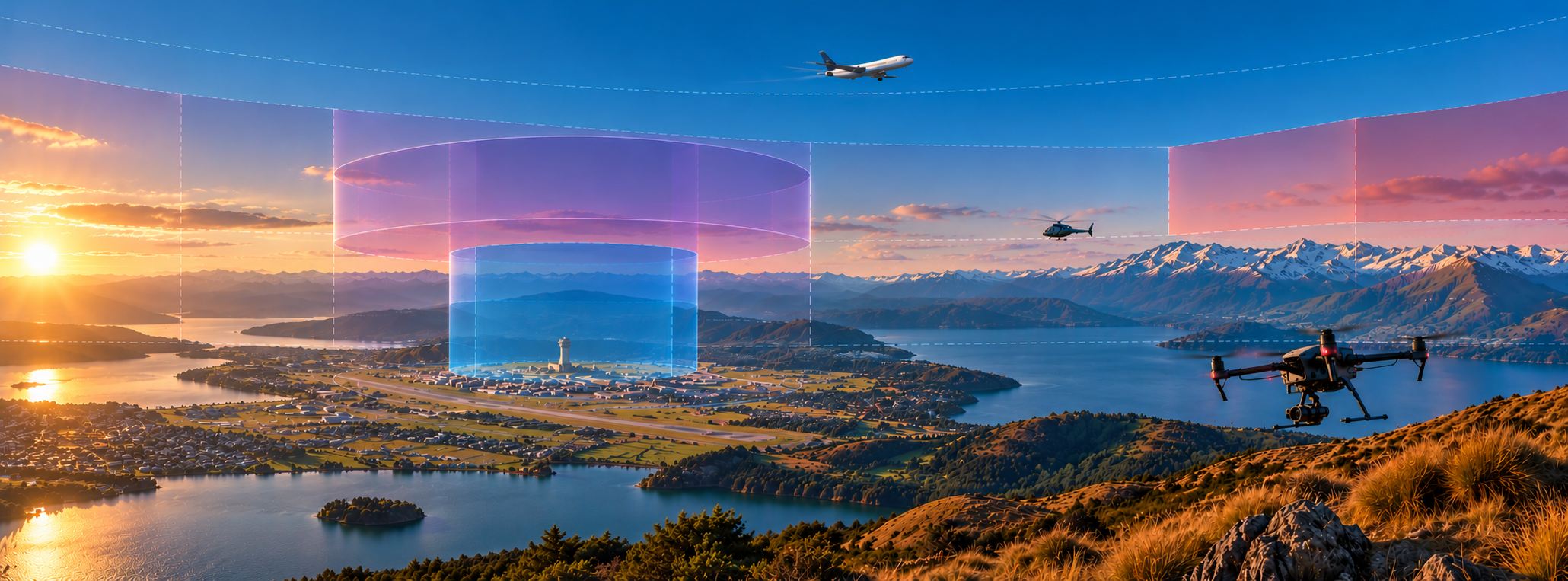
Understanding New Zealand Airspace
A practical guide to airspace classifications, restrictions and flight planning for drone operators.
New Zealand's airspace is shared by a wide range of aircraft, including airliners, helicopters, agricultural aircraft, gliders and unmanned aircraft.
Airspace is divided into different classifications and designated areas, each with its own operating requirements. These arrangements help aircraft operate safely and provide for activities ranging from international airline services to low-level agricultural operations.
For drone operators, understanding airspace is an essential part of flight planning. The rules that apply depend not only on where an aircraft is operating, but also on its altitude, the airspace designation, nearby aerodromes and any restrictions in effect at the time.
This guide explains the airspace system and introduces the tools available to help operators plan their flights, including visual navigation charts, AirShare and HAAST.
CAA Guide: New Zealand Airspace
The Civil Aviation Authority's New Zealand Airspace Good Aviation Practice booklet provides a comprehensive introduction to New Zealand's airspace system.
It explains controlled and uncontrolled airspace, airspace classifications, special-use areas, aeronautical charts and air traffic services, with diagrams and practical guidance for pilots and drone operators.
Understanding airspace
New Zealand's airspace is divided into areas with defined horizontal and vertical boundaries. The classification or designation of an area determines which operating requirements apply and what air traffic services, if any, are provided.
Two fundamental distinctions are important: whether airspace is controlled or uncontrolled, and whether additional restrictions or special conditions apply.
Controlled airspace
Controlled airspace is airspace in which air traffic control provides services according to the applicable airspace classification.
In New Zealand, controlled airspace includes:
Control Zones (CTRs): Controlled airspace extending upward from the surface, generally established around aerodromes where an air traffic control service is provided.
Control Areas (CTAs): Controlled airspace with a specified lower limit above the surface. These areas commonly accommodate aircraft arriving at, departing from or travelling between aerodromes.
For drone operators, controlled airspace is particularly relevant because Part 101 establishes specific requirements for operations within it.
Uncontrolled airspace
Uncontrolled airspace is designated Class G.
Much of New Zealand's lower-level airspace is Class G, particularly away from controlled aerodromes and major aviation routes.
Aircraft operating in Class G do not ordinarily require an air traffic control clearance simply to enter the airspace. However, uncontrolled airspace is still subject to aviation rules, including requirements relating to other aircraft, aerodromes and special use airspace.
Airspace is three-dimensional
Airspace boundaries exist vertically as well as horizontally.
For example, a control area may begin at 2,500 feet above mean sea level, with Class G airspace beneath it. A drone operating near the surface may therefore be outside controlled airspace, even though controlled airspace exists directly overhead.
A control zone, by contrast, normally extends from the surface.
Operators must determine the airspace classification at their actual operating location and altitude, not simply identify the airspace shown above them on a map.
Airspace classifications
New Zealand uses four of the seven ICAO airspace classifications: A, C, D and G.
Each classification establishes the types of flight permitted and the air traffic services provided. For drone operators, the classification also helps determine whether additional authorisation is required.
Class A
Class A is controlled airspace reserved for instrument flight rules (IFR) operations.
It is used at high altitudes and is generally not relevant to ordinary drone operations.
Class C
Class C is controlled airspace used around certain major aerodromes and in designated control areas.
Air traffic control provides services to aircraft operating within this airspace according to the applicable rules.
Drone operations in Class C must satisfy the relevant Part 101 controlled airspace requirements or be conducted under appropriate alternative authorisation.
Class D
Class D is controlled airspace commonly associated with control zones around regional aerodromes.
The air traffic services and separation arrangements differ from Class C, but drone operators must still comply with the applicable controlled airspace requirements.
Class G
Class G is uncontrolled airspace. It includes airspace not otherwise designated as Class A, C or D.
Many routine Part 101 drone operations take place in Class G.
However, Class G may also contain aerodromes, low flying zones, danger areas and other designated airspace. Operators must account for these separately.
Airspace classifications can change
Some controlled airspace is active only during specified hours. Outside those hours, it may revert to Class G.
Other areas may have conditions that depend on activation, published procedures or temporary restrictions.
The current classification and status must therefore be established for the intended time of flight.
Operating near aerodromes
Aerodromes are particularly important for drone operations because crewed aircraft may be taking off, landing or manoeuvring at low altitude.
Part 101 establishes additional requirements for operations on or within 4 km of the boundary of certain aerodromes.
The applicable requirements depend on the type of aerodrome, the pilot's qualifications, the operating arrangements and any relevant exceptions.
Controlled aerodromes
Controlled aerodromes have an air traffic control service.
The associated control zone may extend considerably further than 4 km from the aerodrome, meaning the controlled airspace requirements can apply even when the aircraft is outside the 4 km boundary.
Uncontrolled aerodromes
Uncontrolled aerodromes do not have an air traffic control service managing aerodrome traffic.
Additional Part 101 requirements apply to relevant drone operations within the 4 km boundary, including requirements relating to pilot qualifications, aerodrome operator agreements and observers where applicable.
The 4 km boundary is not an airspace classification
An aerodrome's 4 km boundary and the boundary of controlled airspace are separate concepts.
An operator may be:
Within 4 km of an aerodrome but in Class G airspace.
More than 4 km from an aerodrome but inside a control zone.
Subject to both the aerodrome and controlled airspace requirements.
The distance is measured from the aerodrome boundary, not the centre of the runway.
For a detailed explanation of the applicable Part 101 requirements, see our Part 101 guide.
Special use airspace
Not all airspace restrictions are determined by whether an area is controlled or uncontrolled.
New Zealand also designates areas for activities that require particular operating arrangements, present potential hazards to aviation or involve specialised aircraft operations.
These are known as special use airspace.
Restricted areas
Restricted areas are established where aircraft access must be controlled for specified reasons.
Operations within these areas are subject to the published restrictions and generally require approval from the administering authority.
Military operating areas (MOAs)
Military operating areas accommodate specified military aviation activities.
Entry is subject to the applicable requirements, including approval from the administering authority where required.
Danger areas
Danger areas identify airspace in which activities potentially hazardous to aircraft may occur.
Unlike restricted areas, a danger area designation does not necessarily prohibit entry. However, operators must consider the published activity, activation status and associated risks.
Low flying zones (LFZs)
Low flying zones are designated to accommodate crewed aircraft operating at low altitude.
These areas are particularly relevant to drones because crewed aircraft may operate at heights normally associated with unmanned aircraft.
Part 101 contains specific restrictions on unmanned aircraft operations within designated low flying zones.
Volcanic hazard zones
Volcanic hazard zones identify areas where volcanic activity may present hazards to aviation.
Operators should consider the current status of the area and any associated restrictions, advisories or NOTAMs.
Checking whether an area is active
Some special use airspace is permanently active, while other areas operate only during published hours or when activated.
Operators should consult current aeronautical information to determine the designation, boundaries, activation status and any applicable entry requirements.
A special use airspace designation can overlap controlled or uncontrolled airspace. Both sets of requirements may therefore need to be considered.
Other airspace designations
New Zealand's airspace system includes several additional designations intended to accommodate particular types of aviation activity.
Although these are primarily associated with crewed aircraft, they are useful for drone operators to understand.
Mandatory broadcast zones (MBZs)
Mandatory broadcast zones are areas where aircraft are subject to specified radio communication requirements.
They are commonly established around aerodromes and in areas where increased traffic awareness is important.
An MBZ is not necessarily controlled airspace. Its existence does, however, indicate that aircraft operating in the area may be coordinating their movements through radio broadcasts.
Drone operators should consider the nature of local aircraft activity and any applicable communication requirements.
VFR transit lanes
VFR transit lanes are designated portions of controlled airspace that operate as Class G during their published availability.
They allow qualifying aircraft to transit without the normal controlled airspace clearance requirements, subject to the applicable conditions.
Their boundaries and vertical limits are published in aeronautical information.
General aviation areas (GAAs)
General aviation areas accommodate activities such as gliding, aerobatics and other recreational aviation.
Depending on the designation and activation arrangements, an area may operate as Class G while active.
Drone operators should consider both the airspace status and the types of aircraft activity likely to occur.
Common frequency zones (CFZs)
Common frequency zones identify areas where aircraft may use a published frequency to improve traffic awareness.
Unlike mandatory broadcast zones, a CFZ designation does not itself establish a mandatory broadcast requirement.
These areas can nevertheless provide useful context when assessing local aviation activity.
Finding airspace information
Before operating a drone, the pilot must establish the airspace designation and any restrictions that apply to the proposed flight.
Several sources of aeronautical information are available, each serving a different purpose.
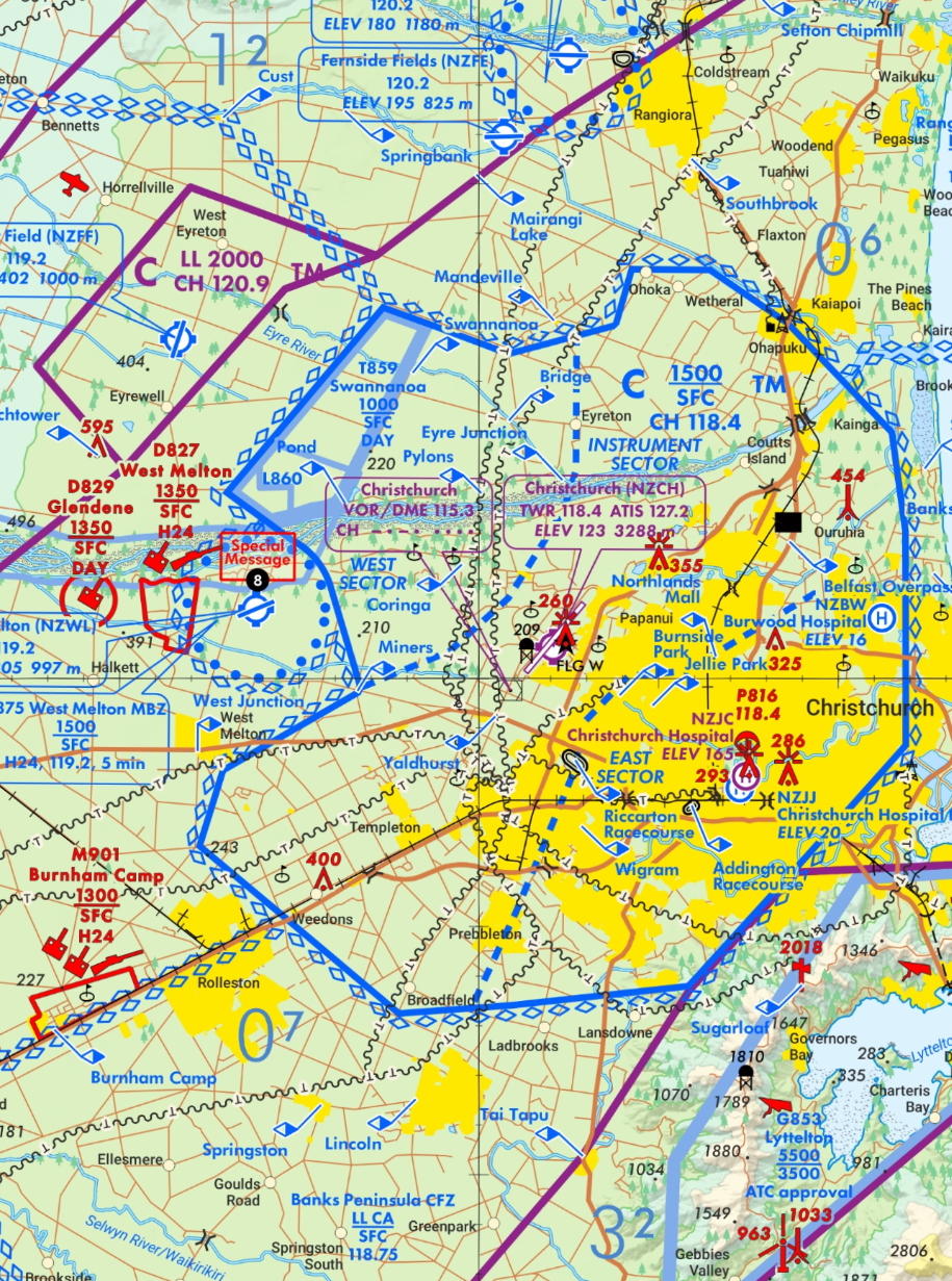
Visual Navigation Charts (VNCs)
Visual Navigation Charts depict New Zealand's airspace structure, including controlled airspace, aerodromes, special use airspace and other relevant designations.
They show both horizontal boundaries and vertical limits, along with frequencies and other information used by pilots.
VNCs are particularly valuable for understanding how different airspace areas relate to each other.
Aeronautical Information Publication (AIP New Zealand)
The AIP contains detailed aeronautical information, including airspace descriptions, aerodrome information, operating procedures and communication requirements.
It provides information that may not be fully represented on a chart.
NOTAMs
NOTAMs communicate operationally significant changes and temporary information affecting aviation.
These may include temporary airspace restrictions, hazardous activities, changes to aerodrome operations and other matters relevant to flight planning.
AIP Supplements
AIP Supplements provide information about temporary or longer-duration changes that may affect aviation operations.
They can be particularly important where temporary airspace arrangements or activities are established for a defined period.
Reading vertical limits
Airspace limits may be expressed as:
SFC: The surface.
AMSL: Above mean sea level.
AGL: Above ground level.
FL: Flight level, referenced to standard atmospheric pressure.
Operators should pay particular attention to the reference used for each limit.
For example, the lower boundary of a control area expressed in feet AMSL is not a fixed height above the ground. The clearance between the terrain and that boundary varies with ground elevation.
A map showing an airspace boundary is only part of the information required. The aircraft's intended altitude, the time of operation and any applicable conditions must also be considered.

AirShare - Drone airspace planning
AirShare is a New Zealand platform designed to help drone operators understand the airspace around them and plan their flights.
It brings together drone-relevant airspace information in a map-based interface and supports flight planning and certain authorisation processes.
Using AirShare
AirShare can assist operators with:
Identifying controlled airspace and nearby aerodromes.
Viewing airspace designations relevant to drone operations.
Planning and recording proposed flights.
Requesting airspace authorisations through supported processes.
Accessing information relevant to operating safely in a particular location.
Airspace authorisations
Where supported, AirShare provides a means of requesting authorisation for drone operations in controlled airspace.
The submission of a flight plan or authorisation request does not itself constitute approval.
Operators must ensure any necessary authorisation has been granted and understand the conditions attached to it.
AirShare and official aeronautical information
AirShare is a useful tool for drone-specific flight planning, but operators remain responsible for checking the applicable rules and obtaining any required permissions.
For complex operations or where information is uncertain, current AIP publications, NOTAMs and the relevant administering authority should also be consulted.
HAAST - Low-level aviation awareness
HAAST is a flight-intention and aviation awareness platform associated with New Zealand Defence Force low-level aviation activities.
It provides a means of sharing information about planned flights and improving awareness of other aviation activity in an area.
Why low-level awareness matters
Many crewed aircraft operate at low altitude, particularly during agricultural work, helicopter operations, military flying and activities in rural areas.
These operations may occur in Class G airspace, away from controlled aerodromes and without air traffic control providing separation between aircraft.
Drone operators should therefore not assume that the absence of controlled airspace means there will be little or no other aircraft activity.
Sharing flight intentions
HAAST can complement other flight planning tools by helping operators communicate planned activities and improve awareness of low-level aviation.
However, HAAST is not an airspace authorisation service. Sharing a flight intention does not replace required approvals or relieve an operator of their responsibilities under the Civil Aviation Rules.
Understanding permissions and authorisations
Depending on the location and nature of a proposed drone operation, several different permissions or authorisations may be required.
These are issued for different purposes and are not interchangeable.
Air traffic control authorisation
Operations within controlled airspace may require authorisation from the responsible air traffic control unit.
Aerodrome operator agreement
Certain operations near uncontrolled aerodromes require arrangements with the aerodrome operator under the applicable Part 101 provisions.
Special use airspace approval
Operations within restricted areas or military operating areas may require approval from the designated administering authority.
Landowner or land manager permission
Permission to access land, launch or recover an aircraft, or conduct activities on land managed by a council, the Department of Conservation or another organisation is separate from airspace authorisation.
Part 102 operating privileges
A certificated Part 102 operator may hold approved arrangements that permit particular activities outside the ordinary Part 101 requirements.
These privileges are specific to the operator and must be established from its Operations Specifications and other applicable conditions.
More than one requirement may apply
A single operation can involve several separate requirements.
For example, a drone flight may take place within controlled airspace, near an aerodrome and over land managed by a public authority.
Obtaining one approval does not necessarily satisfy the others.
Checking the airspace before flight
Understanding the airspace at a proposed operating location should be a routine part of every drone flight.
A practical planning process includes the following steps:
Establish the flight area. Identify where the aircraft will operate and its intended maximum altitude.
Determine the airspace classification. Check whether the operation will take place in controlled or uncontrolled airspace.
Identify nearby aerodromes. Establish whether the applicable aerodrome proximity requirements apply.
Check special use airspace. Identify restricted areas, military operating areas, danger areas, low flying zones and other relevant designations.
Check current aeronautical information. Review relevant NOTAMs, AIP Supplements and published activation arrangements.
Identify required permissions. Determine whether air traffic control, an aerodrome operator, an administering authority or a land manager must provide approval.
Consider other aviation activity. Assess the likelihood of crewed aircraft operating nearby, including low-level aviation.
Confirm conditions before take-off. Ensure the planned operation remains consistent with current airspace information and any authorisation conditions.
Remaining aware during flight
Airspace assessment is not simply a pre-flight exercise.
Operators must remain aware of surrounding aviation activity and changing conditions throughout the flight, maintain the required visual observation and comply with applicable right-of-way and safety requirements.
Tools such as AirShare and HAAST can support planning and awareness, but they do not replace direct observation or the operator's responsibility to conduct the flight safely.
About this guide
This page provides general information about New Zealand airspace and its relevance to unmanned aircraft operations.
It does not replace the Civil Aviation Rules, current aeronautical publications, NOTAMs or authorisations required for individual flights.
Airspace designations and operating conditions may change. Operators should consult current information when planning each flight.